Type to search

Bay Mills Friday, Jun 27, 2025 6:39 AM
Light rain 58°
Today H: 66°
L: 51°
Showers
Tomorrow H: 70°
L: 56°
Sunny
Sunday H: 81°
L: 63°
Dreary
Monday H: 75°
L: 55°
Mostly cloudy w/ t-storms
Tuesday H: 69°
L: 53°
Rain

Islands

Islands with ferry or bridge access (distance from Bay Mills):

Sugar Island (30 minutes)

Sugar Island, located about 30 minutes from Bay Mills, Michigan, is a unique and tranquil destination in Michigan's Upper Peninsula. Known for its natural beauty, rich Indigenous history, and peaceful rural atmosphere, Sugar Island offers a distinct experience for visitors seeking an off-the-beaten-path adventure. Here’s a comprehensive overview of what makes Sugar Island special, including its geography, history, and what to expect when visiting.

Sugar Island sits in the St. Marys River, just southeast of Sault Ste. Marie and about half an hour from Bay Mills. The island is accessible via a short car ferry ride from the mainland, making it both secluded and easy to reach. Sugar Island is known for its quiet, rural landscape, with forested areas, wetlands, and scenic shorelines. It is a haven for outdoor enthusiasts, offering opportunities for fishing, boating, kayaking, and wildlife observation. The island is sparsely populated, with a small year-round community and a number of seasonal residents. There are no large towns or commercial centers, so visitors can expect a peaceful, nature-focused retreat. The island is also significant for its Indigenous heritage, being home to members of Bay Mills Indian Community & the Sault Ste. Marie Tribe of Chippewa Indians. Visitors should be prepared for limited amenities — there are no hotels or major tourist attractions, so it's ideal for those seeking solitude, natural beauty, and a slower pace of life.

Outdoor Activities

  • Kayaking, Swimming, and Fishing: The St. Marys River surrounding Sugar Island offers excellent opportunities for kayaking, swimming, and fishing. The river is renowned for its fishing, with species like salmon, walleye, and northern pike.
  • Birdwatching and Wildlife Viewing: The island’s largely undeveloped landscape is home to diverse wildlife, including moose, migratory birds, and swallowtail butterflies. Birdwatching and exploring the natural habitats are popular activities.
  • Hiking and Exploring: With endless miles of coastline and dense forests dominated by sugar maple trees, Sugar Island is ideal for hiking and exploring. The St. Mary’s River Island Explorer Water Trail provides various landing points for paddlers and adventurers.
    • Sugar Island, located about 30 minutes from Bay Mills, Michigan, offers a rustic and largely undeveloped hiking experience, with its most notable trail system found at the Osborn Preserve.
    • Osborn Preserve Nature Trail
      • Location: Southeastern shore of Sugar Island
      • Size: The preserve covers approximately 3,000 acres and is managed by the University of Michigan for biological research.
      • Trail Details:
        • The main hiking route is an out-and-back trail, roughly 5.5 miles long, with a challenging terrain rating (Petzoldt Rating: 5.90).
        • Trails within the preserve include the Duck Lake, Old Range Light, and Red Rock paths, though they are unblazed and best suited for experienced hikers comfortable with navigation.
        • Elevation varies from 585’ to 610’, with a total elevation gain of about 200 feet.
      • Trailhead Coordinates: 46.353332, -84.136560.
      • Environment: The trail winds through dense woodlands, offering solitude, wildlife viewing, and a peaceful natural setting—especially magical in winter with snow cover.
      • Route Type: Out-and-back.
    • Additional Notes
      • Other Trails: There are no other widely recognized, developed hiking trails on Sugar Island itself. Most of the island remains wild and is best explored by those seeking off-the-beaten-path adventures.
      • Nearby Hiking Options: For more formal or varied hiking experiences, consider nearby trails on the mainland, such as the North Country Trail, Algonquin Trail, and Round Island Point, or regional attractions like Tahquamenon Falls State Park.
  • Beaches: The island features sandy beaches, perfect for relaxing, swimming, or enjoying a sunset. The Sugar Island Resort, for example, offers a sandy beach for guests.

Unique Local Events

Sugar Island Fest: This annual summer festival is a highlight for both locals and visitors. It features live music, local crafts, food vendors, a dance floor, and activities for all ages—including a beanbag tournament, children’s play areas, and camping. The festival is a community-driven event that brings together volunteers and musicians for a weekend of entertainment and fun.

Relaxation and Off-the-Grid Experience

Disconnect from Technology: Many accommodations, like the Sugar Island Resort, intentionally lack cable TV and internet, encouraging visitors to enjoy a peaceful, unplugged retreat.

Cottages and Fishing Resorts: The island is dotted with cottages and small fishing resorts, offering a rustic, off-the-grid lifestyle with amenities like boat rentals and community fire pits.

Scenic and Historic Interest

Freighter Watching: Due to its proximity to the Soo Locks, you can watch large freighters pass by the island, which is a unique sight for visitors.

Potential UN Headquarters Site: Historically, Sugar Island was once considered as a potential location for the United Nations Headquarters in 1945—a quirky historical footnote.

Accessibility

Ferry Access: The island is accessible only by a 24-hour car ferry from Sault Ste. Marie, adding to its secluded charm.

Nearby Attractions

While Sugar Island itself is tranquil and nature-focused, nearby Sault Ste. Marie offers attractions such as the Soo Locks, Kewadin Casino, museums, and historic sites if you’re looking to explore the broader area.

Neebish Island (45 minutes)

Neebish Island is a remote, scenic island in Michigan’s Upper Peninsula, located in the St. Marys River between Lake Superior and Lake Huron, about 45 minutes from Bay Mills, Michigan. It is prized for its natural beauty, quiet rural character, and unique history.

Geography and Access

  • Location: St. Marys River, southeast of Sugar Island, near the U.S.-Canada border.
  • Size: Approximately 21.5 square miles (56 km²), consisting of two main parts: Big Neebish and Little Neebish.
  • Population: Fewer than 100 year-round residents, with a small seasonal community of cottagers and campers.
  • Access: Only accessible by a vehicle/passenger ferry from Bruce Township on the Michigan mainland. The ferry operates year-round and is run by the Eastern Upper Peninsula Transportation Authority.

Natural Features and Wildlife

  • Wildlife: The island is home to a rich variety of wildlife, including deer, moose, bears, bobcats, foxes, coyotes, beavers, otters, muskrats, raccoons, skunks, porcupines, mink, and wolves.
  • Birdlife: Over 200 species of birds have been recorded, making it a birdwatcher’s paradise. Notable species include the Bald Eagle and the rare Kirtland’s Warbler.
  • Flora: Neebish Island boasts more than 100 species of wildflowers, contributing to its reputation as a haven for nature lovers.

History and Culture

  • Indigenous Heritage: Originally inhabited by Ojibwe, Odawa, and Potawatomi peoples. The name "Neebish" comes from the Ojibwe word aniibiish ("leaf").
  • European Settlement: Early European settlers arrived in the 19th century. The island played a role in the fur trade and later hosted a sawmill that operated from 1877 to 1893.
  • Historic Sites: The Neebish Island Lighthouse, built in 1869, offers panoramic views and insight into the island’s maritime history.
  • Community: The island once had several one-room schoolhouses and churches; today, only one church remains, and the community center serves as a hub for gatherings.

Unique Features

  • Shipping Lanes: Neebish Island sits at a junction of the Great Lakes-St. Lawrence Seaway, with freighters passing very close to shore. The island’s east and west channels separate upbound and downbound ship traffic.
  • Adventure Camp: The island was once home to a rustic canoe camp that operated for nearly 30 years, now closed but with visible ruins.
  • Microculture: Neebish Island has a distinctive, close-knit community with its own traditions and history, shaped by its isolation and natural setting.

Practical Considerations

  • Amenities: Very limited — one general store, one campground/resort, and no hotels. Most of the island is undeveloped and private.
  • Transportation: No public transit; roads are rural and quiet. The ferry is the only way to bring vehicles and supplies to the island.
  • Seasonality: Best visited in late spring, summer, or early fall when the ferry operates and the natural beauty is at its peak.
  • Neebish Island is ideal for those seeking solitude, outdoor adventure, and immersion in Michigan’s wild, historic Upper Peninsula. It is not a typical tourist destination but offers a rare glimpse into a unique island lifestyle shaped by nature and history.

Influence on Attractions and Activities

The island’s attractions are directly shaped by its past:

  • Historic Sites: Visitors can explore remnants of the 19th-century sawmill, the old cemetery, and the Pine River Canoe Camp, each telling a story of the island’s economic and social history.
  • Freighter Watching and Waterways: The construction of the West Neebish Channel and the island’s strategic location on Great Lakes shipping lanes make freighter watching a unique activity, connecting today’s visitors to the island’s maritime heritage.
  • Nature and Simplicity: Generations of seasonal cottagers and residents have preserved the island’s undeveloped landscapes, making it a haven for hiking, wildlife viewing, and birdwatching — activities that echo the island’s Indigenous and early settler reliance on the land and water.
  • Community Events: Social gatherings, often organized at the community center, continue traditions of communal celebration and support, reflecting the island’s history of self-sufficiency and togetherness.

Ongoing Transformation

While Neebish Island’s population has declined and shifted toward seasonal residency, new arrivals tend to absorb the established island culture of dedication, resilience, and neighborliness. The island’s history is not just preserved in its landmarks but is lived daily through the values and practices of its community.

Les Cheneaux Islands (45 minutes)

The Les Cheneaux Islands are a picturesque archipelago of 36 small islands in Lake Huron, located along 12 miles of shoreline in Michigan’s southeastern Upper Peninsula, about 45 minutes from Bay Mills, Michigan. Renowned for their natural beauty, rich history, and vibrant resort culture, these islands offer a unique blend of relaxation, adventure, and tradition.

Geography and Setting

  • Location: Southeastern tip of Michigan’s Upper Peninsula, about 30 miles northeast of the Mackinac Bridge and 35 miles south of Sault Ste. Marie.
  • Mainland Communities: Cedarville and Hessel serve as gateways, providing marinas, lodging, restaurants, and shops.
  • Name Origin: “Les Cheneaux” (French for “the Channels”) reflects the intricate network of bays and sheltered waterways between the islands.

History and Heritage

  • Indigenous Roots: The area was originally inhabited and navigated by the Wyandotte and Odawa peoples, who used the channels for travel and fishing.
  • European Exploration: French explorer Jean Nicolet passed through in 1634, and Jacques Marquette mapped the islands in 1671.
  • Fur Trade Era: The islands provided shelter for fur traders traveling between Mackinac and Sault Ste. Marie in the 17th and 18th centuries.
  • Summer Resort Development: In the late 19th and early 20th centuries, the area transformed into a summer resort destination, with the construction of hotels, cottages, and clubs, notably the Les Cheneaux Club on Marquette Island.
  • Conservation: The Aldo Leopold Nature Preserve on Marquette Island is a highlight, named for the famed naturalist who spent summers here.

Unique Features

  • Government Island: The only public island in the archipelago, popular for camping and accessible by boat.
  • Fleet 31: The Les Cheneaux Yacht Club hosts the world’s largest fleet of Ensign sailboats.
  • Protected Waters: The islands’ channels offer safe harbor for small boats and are ideal for exploring by kayak or canoe.
  • Wildlife: The area is a haven for wildlife, including migratory birds and waterfowl, especially in the fall.

Community and Culture

  • Resort Tradition: Many cottages and summer homes have been passed down for generations, fostering a close-knit seasonal community.
  • Art and Festivals: The region is known for its vibrant arts scene, with galleries, festivals, and the annual Festival of the Arts.
  • Conservation Ethic: Designated by The Nature Conservancy as one of the “Last Great Places in the Western Hemisphere,” the islands are celebrated for their pristine waters, air, and forests.

Accessibility

  • Travel: The islands are best accessed via Cedarville or Hessel, with marinas and public boat launches available. Some islands are privately owned, while others (like Government Island) are open to the public.

Recreation and Attractions on Government Island

Government Island, the only public island in the Les Cheneaux Islands, is celebrated for its natural beauty and rustic outdoor experiences. Here are the main recreation opportunities and attractions:

  • Camping
    • Primitive Camping: The island offers rustic, leave-no-trace camping along its shoreline. There are no developed campsites or facilities, so campers must bring all supplies and pack out all waste.
    • Seclusion: The limited access and lack of amenities provide a peaceful, wilderness camping experience.
  • Hiking and Nature Walks
    • Trails: Informal hiking trails wind through birch and conifer forests, allowing visitors to explore the island’s natural habitats.
    • Wildlife Viewing: The island is home to a variety of birds and wildlife, making it ideal for nature observation and photography.
  • Boating and Paddling
    • Access by Water: Government Island is only accessible by boat, kayak, or canoe. The sheltered channels around the island are perfect for paddling and exploring the broader Les Cheneaux archipelago.
    • Picnicking: The island’s scenic shoreline offers several spots for picnics, popular with day-trippers arriving by boat.
Drummond Island (1 hour)

Drummond Island, about one hour from Bay Mills, Michigan, is one of the Upper Peninsula’s most remarkable destinations — known for its size, wild beauty, unique geology, vibrant recreation, and rich history. Drummond Island is a premier destination for outdoor adventure, natural exploration, and unique local experiences. Its diverse landscapes, extensive public lands, and vibrant community offer something for every visitor, in every season.

Geography and Setting

  • Location: Easternmost point of Michigan’s Upper Peninsula, in Lake Huron, just off the coast from DeTour Village.
  • Size: Seventh-largest lake island in the world, third-largest in Lake Huron (after Manitoulin and St. Joseph), and the largest U.S.-owned island in the Great Lakes. The island covers roughly 134 square miles of land and 249 square miles including water.
  • Shoreline: Over 150 miles of shoreline, 30+ bays and coves, and 34 inland lakes.
  • Access: Reachable by a year-round car ferry from DeTour Village. The ferry ride is a unique experience, and in winter, the route may become an ice road.

Population and Community

  • Population: Approximately 1,000 year-round residents, swelling in summer with seasonal visitors and “snowbirds”.
  • Community: The island hosts several small, unincorporated communities, with Drummond Island village as the main hub. The lifestyle is relaxed and self-sufficient, with many residents living off the grid and cherishing the island’s isolation and tranquility.

Outdoor Adventures

  • Off-Roading: Drummond Island boasts Michigan’s largest closed-loop trail system for ATVs, ORVs, and side-by-sides, with over 100 miles of trails traversing forests, rocky outcrops, and shoreline. Turtle Ridge Off Road Park offers 180 acres of challenging terrain for 4x4 vehicles, open spring through fall.
  • Snowmobiling: Voted the #1 place to snowmobile in Michigan, the island features 100 miles of groomed trails for winter exploration.
  • Hiking & Biking: Multiple scenic trails wind through forests, along the shoreline, and across rare alvar grasslands. Both mountain biking and paved paths are available.
  • Kayaking, Canoeing & Paddleboarding: The 56-mile Heritage Water Trail circles the island, with calm waters ideal for paddling. Rentals are available, and the island is a hub for two major water trail systems.
  • Fishing & Hunting: Lake Huron and the island’s inland lakes offer superb fishing for perch, walleye, bass, pike, and trout. Hunting for deer, bear, and upland birds is a long-standing tradition.
  • Golf: The Rock Golf Course is an 18-hole championship course set amid lush forest and dramatic terrain, with stay-and-play packages at the Drummond Island Resort.

Nature and Wildlife

  • Bird Watching: Drummond Island is a hotspot for birders, with eight designated areas on the North Huron Birding Trail and sightings of loons, grebes, owls, osprey, and sandhill cranes.
  • Nature Preserves: Explore Maxton Plains Preserve (one of North America’s largest high-quality alvars), Clyde and Martha Williams Nature Preserve, and Harbor Island National Wildlife Refuge.
  • Wildlife Viewing: The island’s forests and wetlands are home to deer, foxes, coyotes, black bears, and a host of smaller mammals and amphibians.

Water and Shoreline Activities

  • Beaches & Swimming: Several public beaches offer sandy or pebbled shorelines and shallow water, perfect for families and relaxation.
  • Boating: With over 150 miles of shoreline and numerous bays and coves, boating is a favorite pastime. Tall ship cruises and boat tours are available.
  • Scuba Diving: The waters around Drummond Island are home to at least 16 shipwrecks, making it a popular site for divers.

Unique Geological and Historical Sites

  • Alvar Grasslands: Drummond Island’s alvars are the largest remaining high-quality examples in North America, supporting rare plants and unique landscapes.
  • Fossil Ledges: These dramatic limestone outcrops are made up of ancient coral beds and are a must-see for geology enthusiasts.
  • Drummond Island Quarry: A major producer of dolomite, the quarry is a striking feature near the ferry dock.
  • Drummond Island Historical Museum: Features artifacts from Native American, Finnish, and early settler history, as well as the lumber era and the island’s fishing and boating legacy.

Community Events and Local Culture

  • Fall on the Island Festival: Held the second weekend in October, this event features a 5K, craft vendors, live music, food, and autumn activities.
  • Hunter’s Dinner: A tradition for over 40 years, this community meal is held during deer season and features homemade pies and classic fare.
  • Halloween and Winter Events: Ice skating, trunk-or-treat, and other seasonal celebrations bring locals and visitors together.

Other Activities

  • Tennis & Pickleball: Courts are available at the Drummond Island Golf Club and elementary school.
  • Paintball, Skeet & Clay Shooting: Facilities and rentals are available at the resort for friendly competition and skill-building.
  • Tubing & Sledding: Family-friendly tubing hills and sledding are popular in winter, with rentals available.
  • Relaxation: The island’s tranquil setting, scenic drives, and shoreline walks offer ample opportunities for peaceful retreats and photography.

Natural Features and Ecosystems

  • Wilderness: About 87,000 acres of wilderness, much of it state-owned (nearly 60% public land).
  • Ecosystems: Home to more than 13 distinct ecosystems, including six forest types, five swamp-marsh types, inland lakes, rivers, and cobble beaches.
  • Unique Geology: Part of the Niagara Escarpment, with fossil-rich limestone ledges and rare alvar grasslands—especially at Maxton Plains Preserve, one of the world’s finest alvar examples.
  • Wildlife: Abundant game (deer, black bear, grouse), diverse birdlife (including migratory species and arctic-alpine plants), and excellent fishing.

Historical Significance

  • Indigenous Heritage: The Ojibwe called the island Bootaagan-minising (“Mill Island”). It was a traditional meeting and ceremonial ground.
  • British Fort: After the War of 1812, the British built Fort Drummond (1815) on the island, making it the last British outpost on U.S. soil until 1828, when the island was ceded to the United States.
  • Mormon Settlement: In the mid-1800s, Mormons fleeing persecution from Beaver Island established a short-lived settlement here before being driven away again.
  • Logging Era: The late 19th and early 20th centuries saw sawmills and logging communities, some of which (like Maxton) still have remnants.
  • Modern Era: Today, Drummond Island is known for its outdoor recreation, conservation, and as a peaceful retreat.

Unique Features

  • Alvar Grasslands: Maxton Plains Preserve is one of the world’s best examples of alvar, a rare limestone plain ecosystem supporting unique flora.
  • Niagara Escarpment: The island’s eastern cliffs are part of this ancient geologic formation, with fossil beds and dramatic scenery.
  • Public Land: About two-thirds of the island is state-owned, offering vast areas for public recreation.

Climate

  • Summer: Highs in the mid-70s °F, lows in the mid-50s °F.
  • Winter: Highs in the mid-20s °F, lows in the teens, with about 81 inches of annual snowfall.
  • Best Time to Visit: July and August for warm-weather activities; winter for snowmobiling and ice sports.

Getting There

  • Ferry: The Drummond Island Ferry operates year-round from DeTour Village, carrying vehicles and passengers.
  • Highway: M-134 runs through the island, connecting ferry docks and major sites.
Mackinac Island (1 hour)

Mackinac Island, located in Lake Huron at the eastern end of the Straits of Mackinac, is one of Michigan’s most iconic and beloved destinations. Approximately one hour from Bay Mills, the island is world-renowned for its historic charm, car-free streets, natural wonders, and vibrant tourism scene.

Geography and Setting

  • Size: The island covers about 4.35 square miles (11.3 km²) and has an 8-mile (13 km) circumference.
  • Location: Situated between Michigan’s Upper and Lower Peninsulas, accessible by ferry from St. Ignace or Mackinaw City.
  • Topography: Features dramatic limestone bluffs, rock formations, and lush forests. The highest point is Fort Holmes, 320 feet above lake level.

History and Heritage

  • Indigenous Roots: The island’s name comes from the Odawa and Ojibwe word “Mitchimakinak,” meaning “Great Turtle.” It was long home to an Odawa settlement and played a central role in indigenous trade and culture.
  • Colonial Era: Became a strategic fur trading post in the 17th century. The British built Fort Mackinac during the American Revolutionary War, and the island was the site of two battles during the War of 1812 before becoming U.S. territory.
  • Victorian Resort: In the late 19th century, Mackinac Island became a summer resort colony, famous for its grand hotels, Victorian architecture, and preservation efforts. The entire island is now a National Historic Landmark.

Climate

  • Summers: Pleasant and mild, with July highs around 25°C (77°F) and lows near 12°C (54°F).
  • Winters: Cold, with January highs around -4°C (24°F) and lows about -14°C (7°F).
  • Best Time to Visit: Late spring through early fall, when most attractions and accommodations are open and the weather is ideal for outdoor activities.

Main Attractions

Mackinac Island State Park

Covering over 80% of the island, this expansive park features dramatic limestone bluffs, lush forests, rocky beaches, and more than 70 miles of trails. It’s ideal for hiking, biking, horseback riding, and exploring iconic natural landmarks like Arch Rock and Skull Cave. The park’s scenic beauty and accessibility make it the heart of outdoor adventure on the island.

Fort Mackinac

This well-preserved 18th-century fort sits high above the harbor, offering panoramic views and a deep dive into military history. With costumed interpreters, interactive exhibits, and live demonstrations, Fort Mackinac brings the island’s past to life for visitors of all ages.

Mackinac Island State Park Visitors Center

One of the island’s most famous natural landmarks, Arch Rock is a striking limestone arch 146 feet above Lake Huron. It’s accessible by hiking, biking, or carriage tour, and is a must-see for its breathtaking views and geological significance.

Grand Hotel

An icon of Victorian elegance, the Grand Hotel boasts the world’s longest porch and stunning gardens. It’s a destination in itself, offering afternoon tea, historic ambiance, and panoramic views of the Straits of Mackinac. The hotel hosts events and is a favorite for both guests and day visitors.

Horse-Drawn Carriage Tours

With motor vehicles banned, horse-drawn carriage tours are a quintessential way to explore Mackinac Island. These guided rides provide historical insights and a leisurely pace to enjoy the island’s scenery and landmarks.

Biddle House, featuring the Mackinac Island Native American Museum

This historic home and museum highlight the island’s indigenous heritage, offering exhibits on Anishinaabek culture and the island’s early history. It’s an essential stop for understanding Mackinac’s deep Native American roots.

The Original Mackinac Island Butterfly House Gift Shop

A delightful spot for families and nature lovers, the Butterfly House is home to hundreds of free-flying butterflies from around the world. Its tropical gardens and educational programs make it a serene and enchanting experience.

Historic Downtown and Fudge Shops

Downtown Mackinac Island is lined with charming shops, historic buildings, and world-famous fudge makers. Strolling these streets offers a taste of the island’s Victorian-era ambiance and a chance to sample its signature sweet treat.

The Richard & Jane Manoogian Mackinac Art Museum

This museum showcases exceptional collections of Mackinac-related art and photography, providing a cultural complement to the island’s natural and historic attractions.

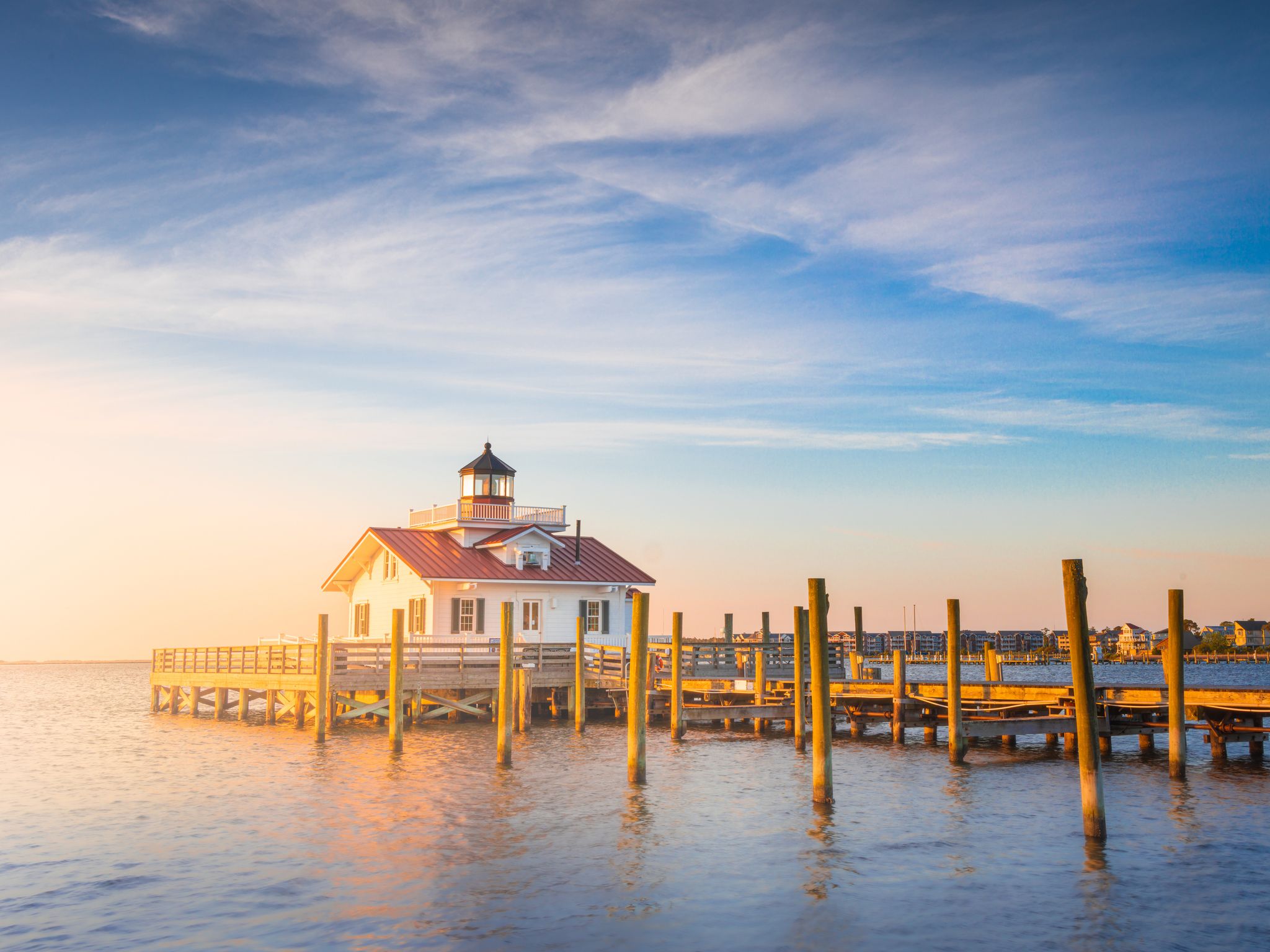
Old Mackinac Point Lighthouse - A Must-See

The Old Mackinac Point Lighthouse is a must-see landmark because it is both a striking piece of maritime history and an immersive visitor experience at the gateway to Michigan’s Upper Peninsula. Here’s why it stands out:

  • Historic Significance: Since 1889, the lighthouse served as a critical navigational aid for ships passing through the treacherous Straits of Mackinac, marking the junction of Lake Michigan and Lake Huron — one of the busiest and most dangerous shipping crossroads in the Great Lakes. Its beacon and fog signal helped countless vessels avoid disaster until it was decommissioned in 1957, following the construction of the Mackinac Bridge.
  • Authentic Restoration and Exhibits: The lighthouse complex is beautifully restored to its early 20th-century appearance. The Keepers’ Quarters are outfitted as they would have been in 1910, offering a glimpse into the daily life of lighthouse keepers and their families. The site features hands-on exhibits, original artifacts, and interpretive displays — including the original Fresnel lens and a gallery on lighthouse optics and fog signals.
  • Straits of Mackinac Shipwreck Museum: Housed in the reconstructed warehouse, this museum showcases artifacts and audiovisual displays about the many shipwrecks in the Straits, adding depth to the maritime story of the region.
  • Tower Climb and Scenic Views: Visitors can climb the lighthouse tower for panoramic views of the Straits of Mackinac, the Mackinac Bridge, and both Lake Michigan and Lake Huron — making it a prime spot for photography and sightseeing.
  • Engaging Programs: Costumed interpreters, demonstrations of the historic fog signal whistle, and audiovisual presentations bring history to life, making the site engaging for all ages.
  • Architectural Uniqueness: The “Castle of the Straits” is built from Cream City brick and Indiana limestone, with a distinctive cylindrical tower and castle-like design unique among Great Lakes lighthouses.
  • Convenient Location: Situated in Mackinaw City, the lighthouse is within walking distance of other historic attractions like Colonial Michilimackinac, making it easy to include in any visit to the area.

Car-Free Tradition

Mackinac Island’s car-free tradition is one of its most defining and cherished features, setting it apart from nearly every other community in the United States. This unique policy originated in 1898, when the arrival of the first “horseless carriage” caused chaos by frightening horses, which were — and still are — central to island transportation and daily life. Local carriage drivers and residents quickly petitioned the village council, leading to an immediate ban on automobiles to ensure the safety of people, horses, and property. The Mackinac Island State Park Commission extended the ban to the state park in 1901, and the policy has remained in place for over 125 years.

The ban was not only a practical response to safety concerns but also a conscious effort to preserve the island’s natural beauty, historic charm, and tranquil atmosphere. Without cars, Mackinac Island feels like a living museum, where visitors can experience Victorian-era streetscapes, well-preserved historic buildings, and a slower pace of life. Transportation is by foot, bicycle, or horse-drawn carriage, making the island safe, peaceful, and exceptionally scenic.

Today, the car-free tradition is a point of pride for residents and a major draw for visitors, offering a rare opportunity to step back in time and enjoy a destination untouched by modern traffic and noise. Emergency vehicles are the only exceptions, ensuring public safety without compromising the island’s unique character. This enduring policy has helped Mackinac Island maintain its reputation as a “Victorian-era escape” and one of America’s top car-free havens.

Natural Wonders

Mackinac Island is renowned for its dramatic natural wonders—unique geological features and scenic landscapes shaped by ancient seas, glaciers, and the passage of time. Here are the most celebrated natural wonders you’ll find on the island:

Arch Rock

A breathtaking natural limestone arch soaring 146 feet above Lake Huron, Arch Rock is the island’s most iconic and photographed natural feature. Formed over thousands of years by wind and water erosion, it frames the sparkling blue waters below and is steeped in Native American legend, believed to be a gateway to the spirit world.

  • Access: Reachable by foot, bike, or horse-drawn carriage; the view from both above and below is spectacular.

Sugar Loaf

The largest limestone stack on the island, Sugar Loaf rises 75 feet from the forest floor in the island’s center. It’s a striking remnant of ancient geological processes and surrounded by legends and folklore.

  • Access: Easily reached via hiking or biking trails; Point Lookout provides a panoramic view.

Mackinac Island State Park

Covering over 80% of the island, the park preserves diverse landscapes — dense forests, open meadows, rugged bluffs, and rocky beaches. With more than 70 miles of trails, it’s a haven for hiking, biking, birdwatching, and nature exploration. The park includes interpretive trails like the Botanical Trail (with 600+ plant species) and the Native American Cultural History Trail.

Skull Cave

A small but storied cave in the island’s interior, Skull Cave is famous for its role in local legend and history—once used as a refuge and burial site.

  • Access: Visit on foot or as part of a carriage tour.

Cave of the Woods & Eagle Point Cave

These secluded caves offer quiet retreats and unique geological interest. Eagle Point Cave, perched on a bluff, also provides excellent birdwatching and lake views.

Tranquil Bluff

A serene, less-traveled bluff with sweeping views of Lake Huron and the island’s forests. It’s ideal for those seeking solitude and natural beauty.

Robinson's Folly

A dramatic cliff on the East Bluff, Robinson’s Folly is a favorite sunrise spot, offering panoramic vistas over the water.

Sunset Rock

Located on the island’s west side, Sunset Rock is the perfect spot to watch the sun dip below Lake Huron, painting the sky with vibrant colors.

Crack-in-the-Island

A literal crack in the island’s limestone foundation, this quirky geological feature is a fun stop for explorers and families.

Botanical Diversity

The island is home to more than 600 species of plants and flowers, best explored along the Botanical Trail, which features interpretive signs and diverse habitats.

Mackinac Island’s natural wonders — like Arch Rock, Sugar Loaf, Skull Cave, and its vast state park—offer stunning scenery, fascinating geology, and rich legends. Whether you’re hiking, biking, or simply taking in the views, these features are central to the island’s enduring appeal for nature lovers and adventurers alike.

Outdoor Activities

Trails

  • Island Perimeter Loop: Ride the iconic 8.2-mile M-185 loop around the island’s shoreline—Michigan’s only state highway where cars are banned. It’s a classic way to see the island, with panoramic lake views and easy access to beaches and picnic spots.
  • Interior Trails: Explore over 70 miles of paved and unpaved trails through forests, bluffs, and meadows. Trails lead to landmarks like Arch Rock, Sugar Loaf, Fort Holmes, and Tranquil Bluff.
  • State Park Trails: Mackinac Island State Park covers more than 80% of the island, with trails for all skill levels. Hike to natural wonders such as Arch Rock, Skull Cave, Crack-in-the-Island, and the island’s highest point, Fort Holmes.
  • Nature Walks: Enjoy peaceful walks through cedar forests, wildflower meadows, and along dramatic bluffs overlooking Lake Huron.

Horseback Riding & Carriage Tours

  • Guided Carriage Tours: Take a narrated horse-drawn carriage tour for a leisurely overview of the island’s history and scenery. It’s a signature Mackinac experience.
  • Horseback Riding: Rent a horse or join a guided trail ride to explore wooded paths and open fields at your own pace.

Water Activities

  • Kayaking & Canoeing: Paddle along the island’s shoreline or join a guided kayak tour for up-close views of limestone cliffs and hidden coves.
  • Boating & Sailing: Charter a boat or join a sailing tour to experience the Straits of Mackinac from the water.
  • Fishing: Cast a line from the shore or book a fishing charter for trout, salmon, and other local species.

Golf

Play a round at one of the island’s historic or scenic golf courses, including the Grand Hotel’s Jewel Golf Course and Mission Point’s putting green.

Wildlife & Nature Observation

  • Birdwatching: The island’s diverse habitats attract a variety of birds, especially during spring and fall migrations.
  • Butterfly House: Visit the Original Mackinac Island Butterfly House & Insect World for a close look at hundreds of butterflies in a lush, tropical setting.

Other Activities

  • Picnicking: Numerous scenic spots around the island are perfect for a lakeside picnic.
  • Photography: Capture stunning views of natural landmarks, historic sites, and vibrant gardens.
  • Parasailing: For a thrilling perspective, try parasailing over the Straits of Mackinac.
  • Mini-Golf & Putting Greens: Enjoy casual fun at Mission Point’s putting green or other local courses.
Islands within paddling distance:

Voyageur Island

Voyageur Island is a hidden gem located in the middle of the St. Marys River near Sault Ste. Marie, Michigan, and is easily accessible from Bay Mills—about a 30-minute drive to Sault Ste. Marie and then a 30-minute paddle by kayak or paddleboard to the island itself. This small, scenic island is celebrated for its tranquil atmosphere, excellent paddling opportunities, and unique blend of rustic and comfortable amenities.

Location and Access

  • Access: Voyageur Island is only accessible by water. Most visitors launch kayaks or paddleboards from either Rotary Park or the Charles T. Harvey Marina in Sault Ste. Marie.
  • Paddle Distance: The journey from Rotary Park to the island typically takes about 30 minutes, making it an ideal half-day or day trip for paddlers of all skill levels.

Features and Amenities

  • Trails: The island features a network of walking paths, including charming boardwalks and rustic hiking trails. These trails are suitable for hikers of all abilities and offer a semi-wilderness experience.
  • Wildlife: The island is a haven for wildlife enthusiasts, with opportunities to spot deer, moose tracks, and a variety of birds. The natural setting provides a peaceful retreat from urban life.
  • Freighter Watching: One of the island’s highlights is its unique vantage points for watching Great Lakes freighters pass by. Benches are strategically placed for visitors to relax and enjoy the view, making it a favorite spot for ship enthusiasts and photographers.
  • Amenities: Voyageur Island offers several comforts, including a compost restroom and numerous benches along the trails. Trail maps are available to help visitors navigate and find the best spots for wildlife and freighter viewing.
  • Winter Access: In winter, the trails are suitable for snowshoeing. The dock is removed in the cold months, so visitors should plan accordingly and be prepared for winter conditions.

Safety and Tips

  • Freighter Safety: While paddling, keep a safe distance from large ships and always wear a personal flotation device.
  • Navigation: Use the provided trail maps and follow posted signs to make the most of your visit.
     

Lime Island

Lime Island is a remote, forested island in the St. Marys River, near the eastern tip of Michigan’s Upper Peninsula and the international border with Canada. It is about two to three miles from the mainland community of Raber and is accessible only by private boat or charter. The island is managed as the Lime Island State Recreation Area and is known for its history, natural beauty, wildlife, and rustic recreational opportunities.

Geography and Setting

  • Size: The island covers about 932 acres (1.41 square miles).
  • Location: Located in the St. Marys River, Chippewa County, Michigan, near several smaller islands including Hart, Edward, Love, Bass Reef, and Little Lime Island.
  • Landscape: The island is heavily wooded with a mix of deciduous and evergreen trees, bluffs rising about 100 feet above the water, and a scenic shoreline.

History

  • Indigenous and Early Settlement: Lime Island was ceded to the United States in the 1836 Treaty of Washington. It was first deeded to Joseph Kemp, a fur trapper, in 1846.
  • Industrial Era: The Pittsburgh Coal Company used Lime Island as a refueling station for Great Lakes freighters starting in the late 1800s. More than a dozen lime kilns were discovered on the island, and limestone was processed here as early as the 1730s.
  • Community: At its peak in 1928, 14 families lived on the island, with a one-room schoolhouse operating from 1913 until the early 1960s.
  • Recent History: The coal dock closed in 1982, and the island was later acquired by the State of Michigan for $1. Restoration of historic structures began in the 1990s, and the Lime Island State Recreation Area was established.

Natural Features and Wildlife

  • Forests: The island is almost completely covered in mature forest, offering habitat for diverse wildlife.
  • Wildlife: Residents include black bears, moose, white-tailed deer, foxes, and snowshoe hares.
  • Birdlife: Lime Island was once home to the largest breeding colony of common terns on the Great Lakes (649 pairs in 1997), though the colony was abandoned in 1999. The area remains important for birdwatching.
  • Elevation: The highest point is about 100 feet above the water.

Recreation and Activities

  • Camping: Walk-in tent camping is available on raised wooden platforms near the docks and on the southeast side of the island (accessible by water or a 2.25-mile trail). Non-platform camping is also allowed in designated areas.
  • Cottages: Two- and three-bedroom barrier-free cottages are available for rent, sleeping up to eight people. Water and portable restrooms are nearby.
  • Hiking: The island features several miles of hiking trails through forest and along the shoreline, with a 2.25-mile trail connecting the harbor to the southeast camping area.
  • Fishing: The surrounding waters offer excellent fishing for walleye, northern pike, yellow perch, and herring.
  • Freighter Watching: The island’s bluffs and shoreline provide excellent vantage points for watching Great Lakes freighters pass by.
  • Picnicking and Beaches: There are picnic areas and a sandy beach for swimming and relaxation.

Facilities and Regulations

  • Access: Visitors must charter or navigate a private boat across the St. Marys River (about 2–3 miles).
  • Motor Vehicles: No public use of motorized vehicles is permitted on the island.
  • Pets: Allowed, but not inside buildings.
  • Food Storage: Food must be secured due to the presence of black bears.
  • Restrooms: Water and portable restrooms are available near cottages and camping areas.

Unique Aspects

  • Historic Structures: Restored schoolhouse and remnants of the industrial era, including lime kilns and coal dock ruins.
  • Isolation: The island’s remote setting and limited access create a peaceful, off-the-grid experience.
  • Sunrises and Sunsets: The island’s bluffs offer beautiful views of both sunrise and sunset over the river.

Rotary Island

Rotary Island Park is a scenic and activity-rich park located on a small island in the St. Marys River, adjacent to Sault Ste. Marie, Michigan, and just a short drive from Bay Mills. This park is a favorite for locals and visitors alike, offering a blend of riverfront recreation, family amenities, and some of the best freighter-watching in the Upper Peninsula.

Location and Access

  • Proximity: Rotary Island Park is immediately adjacent to the Sugar Island Ferry Dock and Clyde’s Drive-In, about 3 miles east of the Soo Locks along Riverside Drive in Sault Ste. Marie.
  • Access: The park is easily accessible by car, with paved parking available. The entrance is about 100 yards south of the Sugar Island Ferry dock.
  • Not Sugar Island: While near the Sugar Island Ferry, Rotary Island Park is not on Sugar Island itself.
  • Features and Amenities:
    • Freighter Watching: The park is renowned for its up-close views of Great Lakes freighters, which pass within 50 yards of the shore. It’s one of the best spots in the region to watch these massive ships, sometimes passing side by side in a “ballet” with the Sugar Island Ferry.
    • Fishing: There is a children’s fishing pond on the inland side of the park, stocked and designed for youth angling. Fishing from the riverbank is also popular.
    • Playground: A playground provides fun for younger visitors.
    • Picnic Facilities: Picnic tables, benches, and grills are available throughout the park, making it ideal for family outings and gatherings.
    • Restrooms: Restrooms (primarily outhouse-style) are available, though some visitors note they are basic.
    • Trails and Sidewalks: There are no formal, named hiking trails specifically on Rotary Island Park near Bay Mills, Michigan, according to available sources. The park is designed primarily for riverside recreation, with paved sidewalks, pathways, and benches that allow for pleasant walks and nature viewing along the St. Marys River. These accessible paths are ideal for leisurely strolls, wildlife observation, and enjoying freighter watching, but they do not constitute traditional hiking trails with marked distances or rugged terrain.
      • If you are seeking a more traditional hiking experience nearby, the Round Island Point Nature Preserve Trail in Brimley offers a 1.6-mile loop through protected habitat with excellent nature viewing opportunities and is suitable for all skill levels. This trail is a short drive from Bay Mills and provides a more immersive hiking experience with views of the bay and opportunities for birdwatching.
    • Wildlife Viewing: The riverside setting offers opportunities to spot local wildlife, both in the water and along the shore.
    • Kayak/Canoe Launch: The lagoon and back channel to the west and south of the island are popular for kayaking and canoeing, with easy access for paddlers. The park is also a popular launch point for trips to nearby Voyageur Island.

Nearby Conveniences

Clyde’s Drive-In: Just 100 yards away, this classic car-hop eatery is a local favorite for burgers and shakes, perfect for a meal before or after your park visit.

Visitor Tips

  • Swimming: Swimming is not recommended in the St. Marys River due to strong currents and cold water, but the lagoon may be suitable for wading or paddling.
  • Finding the Park: For GPS, use the Sugar Island Ferry Dock as a reference point; the park entrance is just south of the dock.

Title

Text if Needed
 

Confirm Trip Deletion

Are you sure you want to delete this trip?

Delete Cancel
User mode: Stranger/Member
Logged In: Not Logged In/Logged In
Trips:
Working trip index: 1
Trip edited: No
Trip has saves: No

Edit my Account info

Optional instructional text here

Create an Account

Some text here

Import Trip Plans - Decommissioned

You or someone using this computer or device previously created Trip Plans.
What should we do with these plans?
Make these Trip Plans part of my account
Discard these Trip Plans

Login

Some text here

Password Reset

Please enter the email you used to set up your account.
We'll send a link to use to reset your password.

Check Your Email

If there is an account with the email address , we will send you a link to reset your password

Create a Trip

Save your favorites to your own customizable trip

Check Your Email

We've sent a link to let you reset your password

Favorites

You currently have no favorites saved.

Save
  • Trip Template
See all of my trips
Create a New Trip
Sign In or Join to preserve your plans:
All Trips
  • Trip Template
 
 
Start Date:  

Day Planner

Drag saved items onto the calendar to plan your trip day by day
Trip Length:   

Adventures

Upcoming Trips

Add New Adventure
Make Active
Trip title
  • days
  • favorites
  • scheduled
  • Edit
  • Day Planner
  • View Favorites
  • Delete

Past Trips

Trip title
  • days
  • favorites
  • scheduled
  • Edit
  • Day Planner
  • View Favorites
  • Delete
Stay in touch
#destinationbaymills
trip
To start planning your next : click the icon
trip
Start time:
Duration: